
Patrik Orcutt 10.21.25

Welcome back to Part 3 of this Multi-part piece I’m writing on my recent trip down the West Branch Penobscot River. If you have not already, I would highly recommend reading Part 1-2 before diving into this one below. In Part One, I have covered the route we plan to take and some info on the participants in this trip. Part two covered the gear I brought and the history of the river.
This trip was not sponsored by anyone, but I would like to thank Old Town Canoe for getting me a Discovery 158 I used for this trip and Jetboil for hooking me up with Flash 1.0 Fast boil system to cook a lot of my meals and make my coffee.
Canoe Coverage on AllOutdoor
The Trip Begins
After meeting up around 3 PM in Bangor, Ridge and myself got all our stuff loaded up and hit the road. We knew we had a long trip ahead of us to get to Roll Dam Campground and wanted to try and get our tents up before dark( That was wishful thinking). The road all the way to the West side of Millinoket is your normal paved highway, but once you hit the Golden Road, that is where the pavement ends. The Golden Road is a 96-mile private road built by the Great Northern Paper Company that stretches from the St. Zacharie Border Crossing to its former mill at Millinocket, Maine. It is still heavily traveled by logging trucks and people looking to recreate in Baxter State Park. While it is mostly a dirt road, it is usually in surprisingly good shape considering the amount of traffic it sees per day. One of the biggest reasons people love to come up to this area of Maine is the natural beauty the landscapes provide. While driving over the Abol Bridge, it is customary to pull off to the side of the road and take in the beauty of the enormous Mt Katahdin.

After driving for about an hour, we got to our first stop at Caribou Checkpoint to pay our road and campsite fees for the North Maine Woods. The North Maine Woods (NMW) spans 3.5 million acres of commercial forest land in northern Maine, characterized by a complex ownership structure stemming from historical land sales in the late 18th and 19th centuries, now involving private individuals, industrial entities, and public interests across 155 townships. The NMW organization, evolving from a 1960s landowner committee into a non-profit corporation by 1981, manages recreational access through uniform regulations and fees, maintaining checkpoints, reducing interior gates, and coordinating with state agencies to facilitate activities like camping, fishing, and hunting while supporting conservation and economic goals for the region.

After passing through the checkpoint, we started making our way to Graveyard Point. The point is part of the Village of Chesuncook, that was established in 1849 by Ansel A. Smith as a logging settlement. Initially an Abenaki encampment, it grew in the 1840s into a frontier logging village after dams on the West Branch Penobscot River, constructed in 1835, 1903, and 1916, enlarged the lake to facilitate log drives. Ultimately with the final drive in 1970 and a cleanup in 1971, marked the end of traditional logging operations in the area. Today, Chesuncook Village is a small, primarily seasonal settlement segmented by outdoor enthusiasts and is accessible by boat, floatplane, snowmobile, and truck. Speaking of getting to Graveyard Point, this proved to be a very time-consuming process.

While the Golden Road was certainly not perfect, you could still manage to drive 30-50 miles per hour in and make good time, while the road into Graveyard Point proved to be much more difficult to pass. While taking the Pine Stream Road is only 13.7 miles on paper, it takes about an hour to travel those 13 miles and then another hour to travel back. This road was so rough with all its washouts and pot-holes, it seemed ironic that the end of the road was called Graveyard Point.
Once we made it through the road to Graveyard Point, we detached my Canoe and strapped it on top of Ridge’s truck while moving all of my necessary gear for the next few days into the bed. We wanted to leave my SUV at the point, to use later as a shuttle, because as with most river trips, this was going to be one way, and we didn’t really feel like walking twenty-something miles back to get the cars. While we were certainly trying to get all the gear moved as quickly as possible, it was impossible not to enjoy the golden light cascading upon us at that point.


With my SUV staged, it was time to drive back out to the Golden Road and make our way to the Roll Damn Campground, where we hoped to have a late Meal and get some rest. On our way out, we would encounter our first Moose of the trip. Naturally, I had the wrong lens on my camera get the best shot of the moose.

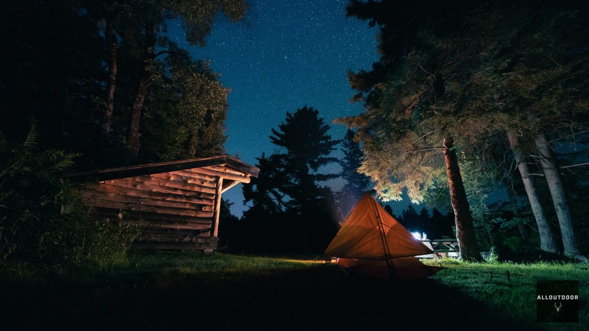
Finally, we reached Roll Damn Campground an hour or so after the sun had set and began setting up camp for the night. Both Ridge and myself were pretty tired at this point and wanted nothing more than a hot meal and some sleep. After making a fire, we set up our tents, and Ridge discovered he had forgotten his tent stakes and pole at his house. Thankfully, there was a lean-to at the campground and he was able to sleep under it that night.


After setting up my tent and eating a meal, I snapped a few pictures of our campground, crawled into my tent, and dozed off for the evening. This is the end of Part 3 of the West Branch Penobscot River trip series. If you enjoyed this, please be on the lookout for part 4, where we get on the river and canoe nearly 20 miles in one day.

Trending Products