
Luke Cuenco 10.02.25

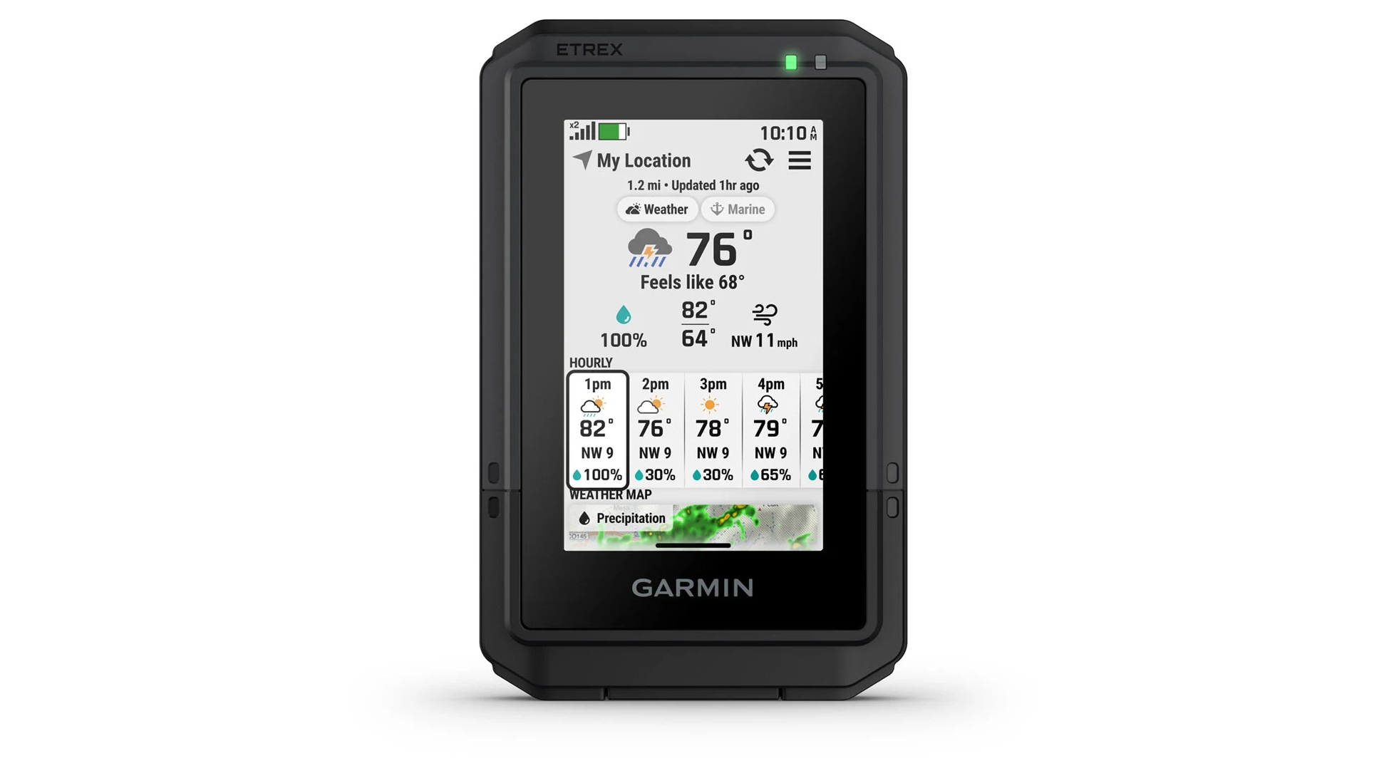
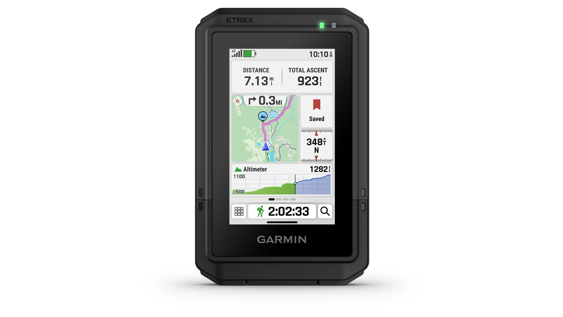
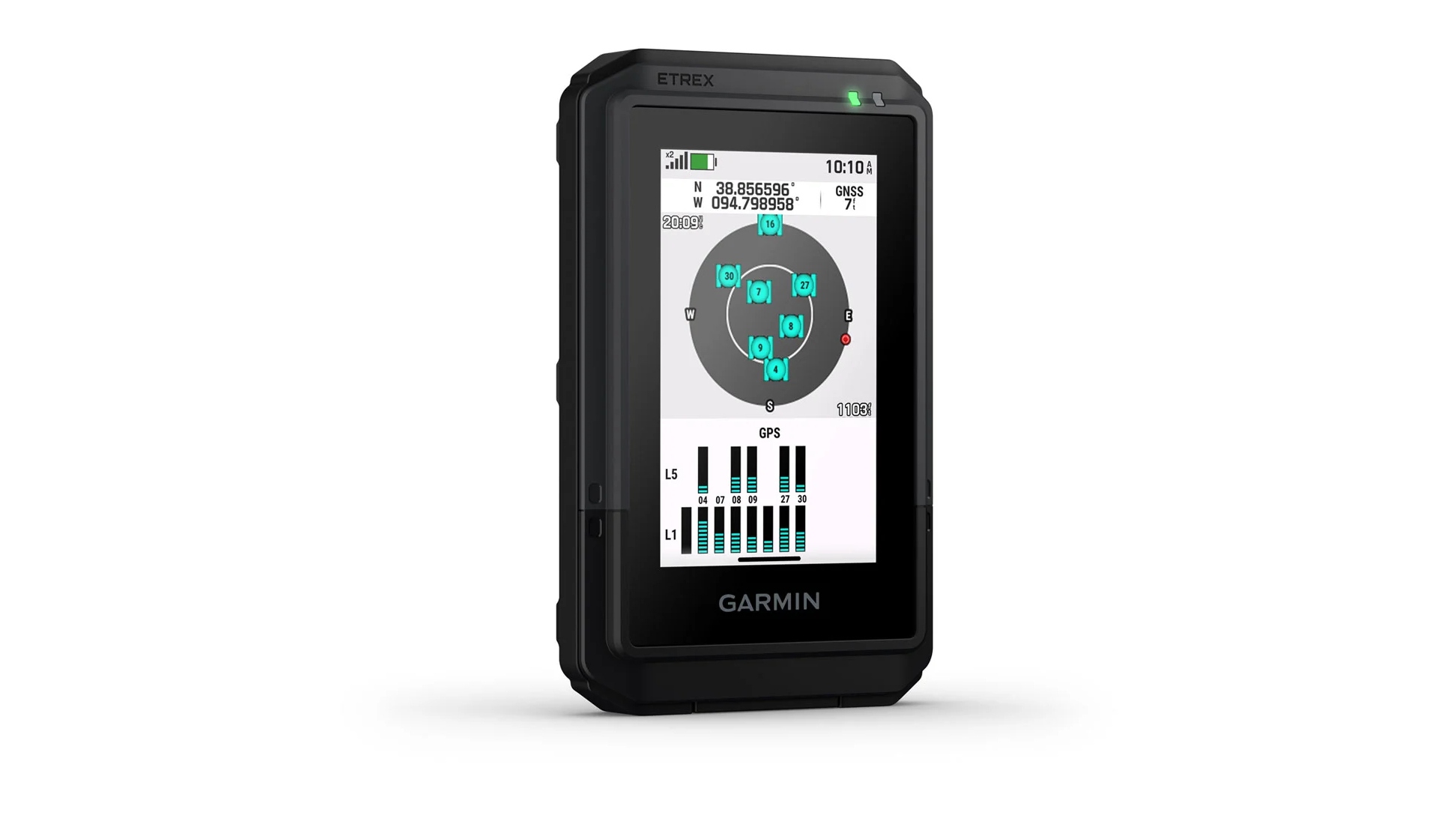
The new Garmin eTrex Touch is built for outdoor enthusiasts who demand reliability and simplicity on every adventure. This compact device features a responsive 3-inch color touchscreen, designed for easy map browsing with tap, swipe, and zoom controls. It comes ready with detailed TopoActive maps, showing trails, roads, elevation contours, and park boundaries, so explorers always know what lies ahead. Multi-band GNSS ensures quick, accurate location tracking, even deep in forests or remote wilderness, making this GPS a dependable hiking companion.
More from Garmin @ OutdoorHub:
Garmin eTrex Touch: The New Ultimate Outdoor GPS
OLATHE, Kan./Sept. 30, 2025/PR Newswire – Garmin (NYSE: GRMN) today introduced the rugged eTrex® Touch GPS handheld navigator – purpose-built for all types of outdoor adventures with a new high-resolution color touchscreen that allows users to easily swipe and zoom in on their routes. Designed to guide adventurers through a wide variety of activities, the eTrex Touch features preloaded TopoActive maps for roads and trails, and the option to add an Outdoor Maps+ plan for access to additional premium mapping content. With up to 130 hours1 of battery life, adventurers can go on entire excursions without needing to recharge.
“No matter the outdoor adventure, the new eTrex Touch will be your essential companion through it. Featuring a bright color touchscreen that lets you tap, swipe and zoom, the eTrex Touch puts advanced mapping and navigation at your fingertips. Combined with rugged durability and dependable battery life, it allows you to enjoy all of your outdoor activities even more.”
–Susan Lyman, Garmin Vice President of Consumer Sales & Marketing
Rugged enough for any environment, the eTrex Touch meets IP67 water and dust resistance and can survive drops and rough handling. Battery life is unmatched—up to 130 hours in normal mode, stretching to 650 hours in expedition mode, so users can explore all weekend or longer without worry. For those who want even more data, Outdoor Maps Plus unlocks satellite imagery and wildlife area details. The device is available now for $449.99 at Garmin’s website and outdoor retailers.
Explore confidently
- Slender design: Light and easy to carry, the newest Garmin handheld navigator boasts a bright, 3-inch, high-resolution touchscreen and fits in the palm of the user’s hand.
- Preloaded maps: View TopoActive Maps for roads and trails, and see terrain contours, topographic elevations, points of interest and more.
- Long battery life: Out of the box, the device offers up to 130 hours of battery life – and up to 650 hours when switched to expedition mode – so outdoor enthusiasts can enjoy activities even longer. When needed, easily recharge with the included charging cable.
- Outdoor Maps+: Add an Outdoor Maps+ plan (sold separately) to receive premium mapping content, including high-detail elevation contours, high-resolution satellite imagery, land boundaries, wildlife areas and more.
- Durable build: Purpose-built to withstand weather and rugged conditions, it has an IP67 dust/water rating and an impact-resistant to MIL-STD-810 specifications design.
- Superior accuracy: Multi-band GPS support provides superior location accuracy, allowing explorers to know exactly where they are on their journey.
- Plan ahead: Connect with the Garmin Explore™ smartphone app for seamless trip planning, or manage waypoints, courses and activities. Users can also see upcoming climbs on their route, when they will occur and how steep they will be.


Trending Products